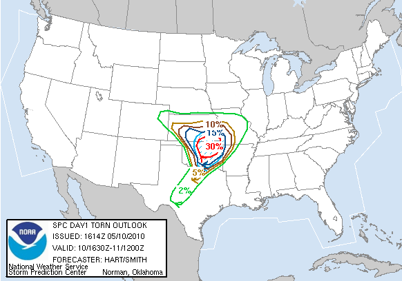
Today was one of those "less than a handful" of days of chase opportunities that come along every year, but for me it was still borderline on whether to go. the spc issued a high risk early in the morning of may 10th. a seasonably strong low pressure with a very intense jet stream over 100 kts was going to move through the central and southern plains. unlike a few of the previous storm systems, moisture would not be a problem, and the shear needed for storms to rotate would be off the charts. about 5 or so days before, forecasts showed the best place to be across most of kansas. as the date arrived though the forecast changed to having the best chance of an outbreak down into texas and oklahoma. even the day before the models were slightly different, but eventually settled on most of oklahoma and extreme southern kansas. i knew i couldn't go all the way down to oklahoma, but when the first day one outlook was issued, there was still a 10% chance of tornadoes across most of kansas increasing to 30% in southeastern kansas in the high risk area. i decided i would wake up in the morning and see how things were looking and then decide whether to go. looking at the models, i tentatively decided to head a little west/soutwest of wichita, kansas somewhere around the kingman, ks area. i woke up to see a lot of cloud cover over most of the risk area which worried me, but this was supposed to clear out. i had a time that i wanted to leave by but unfortunately didn't get going until about an hour later than planned. this would come back to bite me! i left town around 1245 and headed west on I-80, and then south on hwy 81 through nebraska and into central kansas. it was rainy, windy, and very cool all the way to central kansas. storms were starting to fire in southwest and western kansas already. as i got closer to wichita some of the first storms were starting to reach me with heavy rain and lightning. there was finally one monster storm that developed southwest of wichita heading towards the east/northeast at 50-60 mph. one of the reasons there was a high risk that day was for strong, long track tornadoes, and the reason for the threat of long track tornadoes was because of the storm motions expected to be near 50-60 mph. back to the storm heading towards wichita, it was located near kingman, kansas! as i raced south to try and get it front of it, i couldn't help but think i should already be there. this is a bad habit i've developed storm chasing where i don't leave when i want to, and then miss something big. this usually happens on longer trips where i try to debate whether i should even go or not because of how far the drive will be. it's something that i need to fix! well, i didn't make it down there in time to get in front of the storm where i wanted to. i was approaching wichita at rush hour and didn't want to have to worry about being on a crowded highway with a possible tornado bearing down on me and no way to escape. so i decided to head east and then south around wichita. unfortunately the storm died as it approached and then passed by wichita. by the time it reached me there was just some gusty winds and small hail. i was given a taste though just how dangerous it could have been. the storm bases were basically on the ground. it looked like i could have thrown a baseball up into the clouds they were so low. also they were moving extremely fast and the shear was obvious in the clouds as they were moving in all different directions. so after driving for four hours, i spent about 45 minutes east of wichita, and then turned around to make the long drive home.


the first day one outlooks tornado chances hail chances


1630Z outlooks
here are some radar grabs of the storm near kingman, ks. look at that hook!!


velocity images, notice the couplet(green next to red) strong signs of rotation!


on my way home there was one last small line of tstorms that became warned as i was driving towards them. i was heading north on I-135 and the storms were heading east towards me. i stopped right near mcpherson, kansas on a highway overpass to let the storm come over me. it was warned for quarter sized hail and winds up to 60 mph. at one point the hail indicator indicated over 2" hail as it was approaching. of course, the storm weakened once it finally reached me, but winds were still over 40 mph and there was some pea sized hail. i took a series of great pics as it approached.


meanwhile there was a tornado outbreak ongoing in oklahoma. several suburbs of oklahoma city and other areas of north central to eastern oklahoma were hit by strong tornadoes. i grabbed some radar images of one of the first storms that was ongoing while i was approaching wichita. again a textbook example of supercell with an amazing hook!!


finally on my way home, i was stopped and received a stupid speeding ticket! i was just pulling into some small town where the speed limit drops down to 55. i had just started slowing down, but not fast enough bc there was a cop basically right on the other side of the sign where it changed. so he got me for going 69 in a 55, a $123 ticket!! he asked where i was coming from and i told him storm chasing but he only seemed mildly interested and then gave me a ticket anyways! so what did i learn from today's chase? commit to a chase earlier, high risks chase are always "risky" bc they can involve storms that move way too fast to even keep up with, and lastly follow all posted speed limits!


No comments:
Post a Comment