Saturday, April 24, 2010

4/23/10 Eastern Nebraska

I had another "disappointing" chase today, so to speak. Everything looked pretty good for several tornadoes, and even a couple a days prior the Storm Prediction Center was worried about a lot of tornadoes with some possibly strong. The day of the chase they backed down on their wording, but there was still a 10% chance of tornadoes, which is pretty darn good! i asked sarah to come along since it was going to be a close chase and this seemed like a pretty sure bet to see something cool. it's been pretty ironic though, everytime sarah has come with nothing has really happened! we left about 130 and headed west on the interstate past lincoln. there was a tornado watch issued for central and western nebraska and the storms were supposed to form along an arc from western to central to southeast nebraska and then move north. we went as far west as seward, nebraska and then waited. and waited, and waited...... at first the clouds were mushy looking, but finally they started to get bigger and taller. we looked back towards the east and thats where they were really starting to look good. so we started heading back towards omaha! i had several small computer issues today and that slowed me down a few times, how annoying! once the radar wasnt working, another time my internet quit, another time my gps mapping software quit. each time i had to restart the computer. we eventually ended up back on hwy 6 and 30 just north of elkhorn(only about 10 miles from home!) and waited for a small thundershower to move over us. the storm clouds were looking alot better, but didn't show much on the radar. finally a few more cells popped up southeast of lincoln and those at first didn't do much, but suddenly went severe. so we started heading back south. i took hwy 92 i believe west towards wahoo, nebraska. then we headed south. it was getting dark at this point(8 oclock), but just to see something we were going to drive in front of the storms and let them come over us. they were severe warned now with quarter sized hail. as we headed south and found a road to sit on and wait, the storm went tornado warned!! the circulation was going to pass just west of us, and knowing storms can turn right without warning i wanted to get a little further east. we meandered east around memphis, nebraska(town ive never hear of!) and waited there. the hail size was now showing 2" which is bigger than golf balls so we sat there and waited to get hit. unfortunately the storm weakened a little and the biggest hail was marbles with maybe a few quarters. finally we headed back home, stopping along the hwy between gretna and elkhorn to get some lightning pics. i am still learning my fancy camera, and so there were several times once it got dark where i just couldn't do anything with it so eventually i had to use sarah's trusty ol camera. it does take good lightning pics though!! so we did end up on the only tornado warned storm of the day, but couldn't see much bc it was already dark. didn't get any real good lightning pics, and oh yeah sarah and i almost got hit:( it wasn't as bad as it sounds, but when we were pulled off at the last spot taking pics, i should have put on my hazards, but didn't. a car was heading towards us down the gravel road and we were sure they would see us in the headlights, but apparently they didn't til the last couple of seconds. it was close enough where i flinched and stepped on sarah's toe!! i will always put on my hazards now, especially at night!! here's hoping to an active may and june!


forecast sounding for omaha at 4p, notice the large curved hodograph, lot's of CAPE, and no cap. unfortunately there ended up being a cap between 700-750 mb level


tornado risk for the day

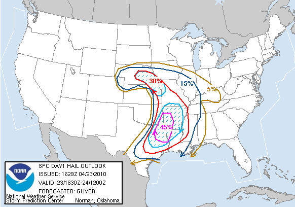
hail risk for the day

towers finally popping!

tall, leaning tower of a storm near omaha now

first big tower to go up

another storm trying to develop

tornado warned storm south of wahoo, ne

pic of storm west of omaha

again, notice the hail shaft just to the left of the middle

again

Thursday, April 8, 2010

4/5/10 First chase of 2010 season

Well i went out on my first chase of the new season this past monday. Unfortunately didn't see much, but it was nice to get out since the last time i had gone out was back in may of last year, before the malibu was wrecked. the day before i set up the laptop mount, with some great help from my wonderful wife, and got the car "ready". i was excited to try out some new stuff i had received over the the past several months. last year i had a garmin that i of course used for navigating. it was pretty helpful obviously, but using it had some restrictions, like map details and having to type in stuff while trying to drive, etc. so i bought microsoft streets and maps and put that on my computer. it does alot of the same things as the garmin, but it also has maps that are alot more detailed and easy to navigate around. the other nice thing that came with it was a gps puck. this is just a cord with a small gps receiver on the end of it that i can plug into my computer and then i can use gps on the streets and maps program. thats the other reason why i bought this software bc i can also use the gps function to then plot where i am at on my fancy radar program i have, grlevel3. this is nice bc then i know exactly where i am at in relation to the storm.
alright back to the chase! the setup today was a strong warmfront that was lifting north during the day into southeast nebraska and eastwards along the missouri/iowa border. south of the front temps were into the 80's and north of the front omaha basically stayed in the upper 50s all day. there was incredible shear along this front. at one point the 0-1 km helicity was 600 m/s2!! that's at least 4x the amount normally needed for rotating storms and tornadoes!! unfortunately there wasn't really anything to kick off storms that day so it was a "hope and pray" day for tstorms. hope that there would be something little to set off the storms or enough heating to get em to go up. i headed south along I-29 and as i reached just north of falls city, it became sunny and very warm instantly. i stopped at a place called oregon, mo, to wait for storms. the storm prediction center was monitoring the possiblilty of storms firing soon. i waited for about 45 mins watching the data on my computer. i decided that the front was getting a little to far north of me so i started to head north and east a little bit and ended up east/southeast of maryville, mo. for a while things looked promising as towering cumulus started to develop. but, unfortunately they couldn't sustain themselves and would fizzle out. finally around 7 i decided to call it a day, when my radar updated with some storms rapidly developing back to my southwest in northeast kansas. i was running out of daylight but thought i could race back to falls city, neb and meet them in that area right around sunset. i made it back in time, but on my way back they didn't really get much more severe than some hail. i stopped along the interstate at one point to try and get some pics of the storm but it was already too close. i am still getting familiar with all the settings on my new camera that i also got over the winter, so i spent most of the time fiddling with the camera rather than taking pics. it wasn't long though before the storm overtook me with heavy rain and some pea sized hail. it was here where i really used the gps feature now on my radar to drive back exactly into the core of the storm, but again it was only small hail. i continued to head home to omaha, arriving around 1030 pm. some elevated storms with small hail developed southwest of omaha and moved into town after midnight with some intense sheet lightning and heavy rain and small hail. i received 1/2 inch of rain at my house. so overall not a great chase but it was nice to get out for the first time in 10 months. the season is still real early, so i hope it gets better! here's a picture to the path i took that day, another nice thing about this new program i have!! i also included the risk probabilities and some of the hodographs that showed the intense shear in the sky.


path i took


severe probabilities for the day

tornado chances for the day


hodograph along ia/mo border


hodograph near carrol, ia-this was way north of the front though so no real chance of tornadoes here