
pics of what was left of the first storms, taken east of Adams, NE
i was seriously planning on heading southeast towards nebraska city or in that area, bc there the moisture was way better with dewpoints in the mid to upper 50s. i messed around taking some pictures and there were more storms that had developed in nearly the same spot as the first storms in northern kansas. these storms were strengthening and heading towards the border. nothing else was looking great so i decided to head south of beatrice and meet these storms. i took a couple more pics of the high based storms developing.


the storms continued to strengthen down in kansas as the moved north. one cell became tornado warned and soon a report of a tornado on the ground was reported! i ended up south of beatrice and met the storms, but unfortunately they had weakened again in the lower moisture and was no longer tornado warned. the storm still had some good rotation, and i took some good video of scud forming out of mid air and rising into the storm as it tried one more time to form a wall cloud. below are a couple of pics of this happening near odell, nebraska.


again more storms had fired in the same spot in kansas and were moving north towards southern nebraska, this time a little further west. at first i figured these storms would die as well as they came closer, but they were looking really good on radar and were tornado warned as well. so after briefly heading north towards beatrice to start heading home, i turned around and thought i would try to meet the storms again and at least get some more pics before dark. as i headed back west on hwy 8 towards odell, i looked up and saw these amazing mamatus clouds.


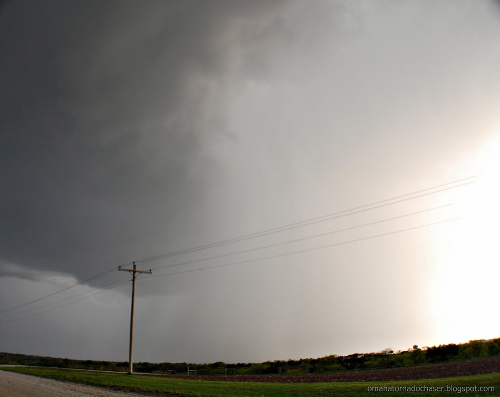
the storm was still looking really good as it now headed towards fairbury, ne. i contunued to head west on hwy 8, stopping at little county roads to get pictures of the amazing shelf cloud that was coming into view. the anvil of the storm had amazing lightning shooting out of it and i was able to get one shot of it.

here are some pics of the shelf cloud coming into view


the last stop i made was just east of the town steele city. i couldn't see the town from where i was at but could hear the sirens blaring. the storms were moving at 50-55 mph, and suddenly the storm was basically on top of me just to my northwest. i hadn't been looking at the radar real closely, but looked at it now to see an amazing hook on the storm and it was still tornado warned. radar was also showing almost baseball sized hail!! the shelf cloud was bright grayish-white when compared to the dark storm clouds behind it. i had turned onto a gravel county road that was pretty muddy from the previous storms that had already passed through. i headed north about 1/4 to 1/2 mile. the storm was now passing directly to my north, and had some of the most intense motions i've ever seen! i could hear the wind coming and it became really windy at my spot. i was near some powerlines so i drove backwards back down the gravel road to the highway and headed back east on hwy 8 so i could head north towards beatrice. here are some pics of the storm from the gravel road. apparently there was a tornado that was on the ground at this point that was rated an EF-1. it took out a ton of powerpoles and knocked over a center pivot. looking at the map it was only about 4 miles from me!
the pics below show the storm crossing the road in front of me. on the last 3 pics you can see a lowering thats basically above the road. that might be the tornado?!


link to damage survey of tornado: http://www.crh.noaa.gov/news/display_cmsstory.php?wfo=oax&storyid=51691&source=2
as i headed back east on hwy 8 and then north towards beatrice, there were continued tornado warnings and report of a tornado on the ground near beatrice, but i haven't seen that confirmed. i stayed behind the storm and it eventually weakened a little. it was dark now so i headed towards home. on the way i stopped to take some lightning pics as there were storms all around me that had amazing lightning. the first spot i stopped was along the hwy on the shoulder. i got out of my car to set up my tripod. there was a house down a gravel road about 1/2 mile and i could hear a dog barking presumably at me. i ignored it at first but it sounded like he was getting closer! so i hopped back in the car and used my little tripod to rest sarah's camera and took some pics there. the clouds were moving so fast though they came out blurry. i also got out my new camera and was able to get one good pic before the rain started again.


as i headed north there was one more impressive storm that was going to cross in front of me. this storm would have been amazing to see in the daylight! it had a huge shelf cloud that was being backlit by constant lightning. this shelf cloud was huge and looked like it was basically on the ground!! i should have just gotten out and taken some pics with sarah's camera, but i wanted to take them with my camera. i pulled over onto the muddy shoulder, and had to try and set up my tripod and attach the camera, etc. then i went to take the pics and my camera wouldn't work!! by the time i got it figured out, the storm was on top of me and the wind was howling and it started raining. i was so mad!! the rest of the trip home was spent driving through pouring rain, and oddly enough areas of really dense fog, which was odd for how windy it was and how hard it was raining.
here's some images of the outlooks issued, the tornado watch issued, and the forecast hodographs which did show the low level shear really increasing after 7pm.


map of route driven


No comments:
Post a Comment