Thursday, May 26, 2011

5/24/11 The I now hate Kansas chase!!

This day was my 3rd chase to Kansas in the last 13 days, and perhaps the most disappointing. Today ended up being the feared high risk bust day. I had been watching this day for most of the week leading up to it. All the ingredients were coming into place for a potential outbreak of strong to violent tornadoes. At first, the best area looked like it would be south into Oklahoma, but the area shifted further north and the day before looked like most of Kansas and Oklahoma would be in a high risk area. When the first day 1 outlook came out it left most of Kansas out of the high risk except from about Wichita on south.
I decided my friend and I would head down towards Wichita. We left town about 1030, and by 2-230 storms were already firing and tornado watches were being issued. The first storms formed down in Oklahoma, and were expected to move into Kansas. Watching things on radar though, it seemed like it would be quite a while before those storms made it into Kansas. There was one storm though that had split left and was heading due north into Kansas. About the time we got to Kingman, more storms were filling in rapidly west of Wichita. The storm from Oklahoma had moved up towards Pratt, and was warned for baseball sized hail!
Around this time, I was looking at the parameters for tornadoes and there was quite an area in southcentral Kansas that didn't have very good shear for some reason. So we decided to try and head west to Pratt and then come in from behind on the storm moving north. There were also tornado warned storms that were moving east along the warm front in western Kansas. This would be our new target area.
As we headed west towards Pratt, the winds picked up dramatically from the south. It was very warm here and not as humid so the cloud bases were pretty high, in fact too high for tornadoes. But i knew as the storm moved north they would lower. With the strong winds, there was a ton of blowing dust and even some gustnadoes forming out in the fields. The winds continued to increase til they were probably averaging around 40 mph. As we passed a grove of trees small branches were breaking off and leaves and other debris were flying across the highway. A semi heading towards was actually pushed into our lane briefly as it came out past a break of trees. Luckily, he was able to correct himself!
We made it to Pratt and headed north and were probably about 15 miles or so behind the storm. It was moving around 45 mph so it took a while to catch up. We were finally within about 5-7 miles of the storm when traffic started slowing down and we could see flashing lights. Then we noticed some tree damage with some pieces blown across the highway. Also there was a large center pivot out in a field that had been blown over. It looked like a possible tornado had just come through here! A fireman, came up to our car and said the road would be closed for a while and directed us to take a county road to go around to the north. The road was dirt though and since the storm had moved through was really muddy. We made an attempt at driving on it and made it about a mile or so, but it was very sketchy at best and I didn't want to get stuck and ruin the rest of the chase so we turned around.
It was also at this point though that we lost our internet connection. Things were going downhill for us rapidly! Driving "blind" so to speak we went back south to the next main east/west highway and turned east. We found internet coverage again a couple of miles down the road and soon discovered there were more tornado warned storms to our north and west. We made our way back to Great Bend which was the original town we were heading towards before the highway was blocked, and then continued on northwest. We could see the intense storm that reportedly had a confirmed tornado with it minutes before. The storm was dark and mean looking, and once we were close enough we stopped to take video and pics.
The storm however had started to become outflow dominant and had turned to the east in it's movement. Also storms had rapidly started filling in to the south of the this storm. We found ourselves getting overtaken by the storms. We headed back southeast towards Great Bend, but the storms overtook us with very heavy rain and winds to near 50 mph. Eventually, we made it ahead of the line east of Great Bend. The storms had formed into a continuous line now as the dryline filled in, pretty much killing any chances of tornadoes. For the last hour or so of daylight we would get ahead of the line, stop and take some pics as it approached and then do it again one more time before letting the line overtake us with nickel sized hail and gusty winds. We then made the long drive home arriving around 130 in the morning.
To me the day was a high risk bust. There were tornadoes and a few strong ones in Oklahoma, but for all the wordings and warnings of an outbreak, this definitely did not meet up to it's hype. On the way home we did hear of 2 fatalities in Kansas due to a falling tree going through a van. It turns out this was the reason why the highway was closed in the direction we were going. The tornado couldn't have passed through there more than 5-7 minutes before us. We were left wondering both whether that could have been our car, or what kind of a view of a tornado we possibly missed. I don't feel like we would have been hit, because I doubt we would have been in the middle of the storm. Normally, I don't have a problem going into a storm with large hail however, this storm was warned for baseball to softball sized hail which is a size I won't mess with! So we would have probably stayed behind the storm if we had caught up with it earlier. Who knows, we might have seen a tornado then?
The last 3 trips to Kansas, I've traveled over 2400 miles, spent over 45 hours in the car, and didn't see a stupid tornado. Here's hoping June will give me better luck, but as it looks like right now most of the first week of June will be hot and dry over most of the central U.S.


day 2 outlook- huge area with a very high risk

day 1 outlook 1130 am

day 1 1130 am tornado outlook. note the 45% prob. this is rare to see!!

day 1 1130 am hail probs. note the 60% prob. again, very rare to see this high!

day 1 outlook 3 pm

day 1 outlook 3 pm tornado probs

some of the forecast hodographs in Kansas. Shear looked amazing as reflected by the long curving images


this hodograph actually had the shear going off the chart!


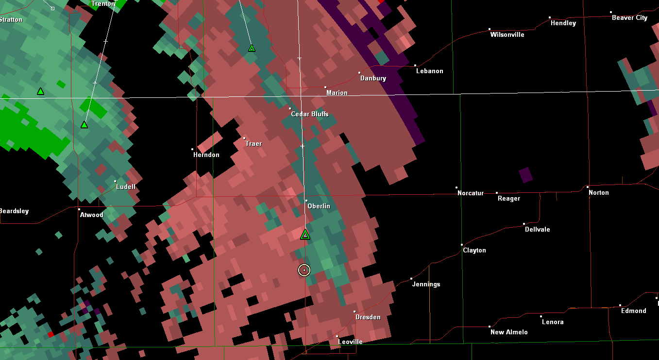
radar grab of the storms about 5 pm. we are the white circle with the dot in the middle north of pratt.


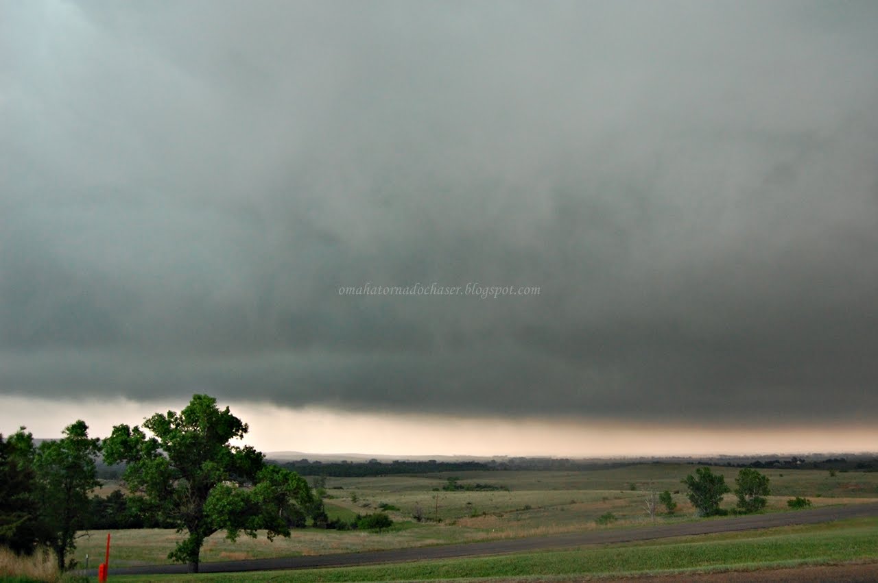
first pic of tornado warned storm as we approached

getting a bit closer

again

one of my favorite pics. we were now parked and almost directly underneath it!

again


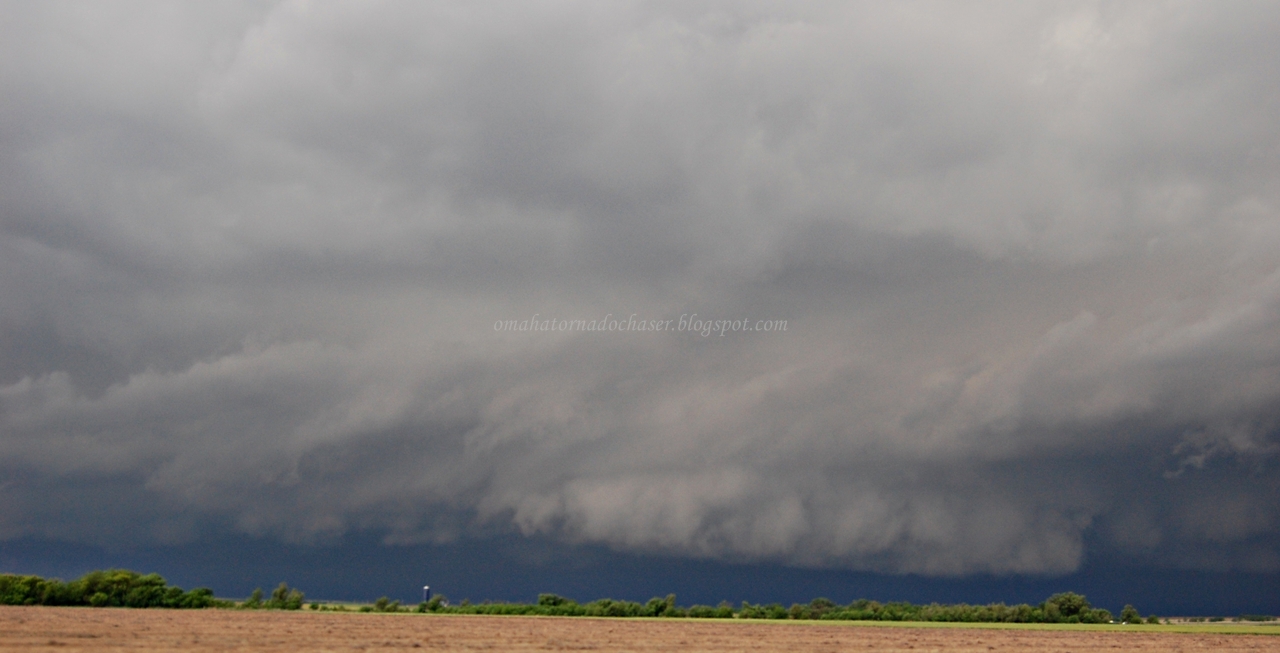
view of the weaker line and shelf cloud

again

another image of the line of storms


last shot of the night

damage survey to the 2 main tornadoes in our area. the first survey is for the tornado that caused the 2 fatalities on the highway in front of us. The tornado was an EF-2 with winds estimated at 120 mph:
storm survey


Total miles driven: 864 miles
largest hail: nickel
strongest winds: 50-55 mph

Wednesday, May 25, 2011

5/19/11 another disappointing Kansas chase

This day was my second marathon chase to Kansas in 2 weeks. Originally this day didn't look that great, but as the day approached the ingredients were looking better and better. I watched it close and decided this could still be a good day to go out. A friend of mine wanted to come along and we left town at about 1030 in the morning with an initial target around Great Bend, KS. The atmosphere in Kansas was rapidly destabilizing as we headed south. Wind shear was increasing and it looked like things could be even better than expected. We arrived at the town of Hollyrood, KS and storms were just starting to fire north and west of us towards Russell. About that time the Storm Prediction Center raised the risk to a moderate risk with a chance of strong tornadoes! We waited around to make sure the storms got a little better organized before heading towards them.
As we approached our storm, it was severe warned for large hail and strong winds only. There was another storm to its northwest that was tornado warned, but we opted to stay on the further south storm. We approached it from the east on a road right next to I-70. When we got close enough we could see rapid rotation in a wall cloud and little funnels dipping down briefly! The inflow into the storm was very strong as well, with the winds probably constantly being above 40 mph! We were sure a tornado was going to drop. We pulled off to the side of the road and watched the storm spin. Eventually, we realized it was heading right towards us but the rotation was weakening. We turned the car around to head east to get back out in front of it. We headed north of I-70 near Wilson and drove by Wilson State Park and the huge lake it sits on. The sky was green and created a beautiful scene as the storm moved over the lake. There were reports of a rain wrapped tornado about this time, but we didn't see anything. We headed towards the town of Sylvan Grove that was directly in the path of the storm, again stopping to take pics and video. We were at the back part of the storm and possibly saw the rain wrapped tornado as we saw rain curtains wrapping around rapidly. From Sylvan Grove we went north a bit and then east on Hwy 10. The storm had began to turn into a huge blob that made it seem even more impossible that we would see a tornado. We stayed out in front of it for awhile stopping every 5-10 miles or so to watch it, before it started to weaken and head north.
Suddenly there really wasn't any big storms to watch and we were looking at starting the trip home by 730. One last storm did pop though and we backtracked a bit to let it go over us in the town of Beverly. Radar showed this to have large hail, but not a stone fell where we were. I was getting even more frustrated! We made an attempt to follow this storm north as it grew as well but our closest option was a muddy gravel road, that we didn't want to drive on. So we headed back to Hwy 81 to head north and back in the direction of home. This last storm that had developed did cross the highway and we experienced nickel sized hail. It was heading northeast and I saw there would be another highway it would cross. We turned off on Hwy 24 to get back in front of the storm. I love getting into hailstorms with my car, since it isn't worth anything, I don't care about any dings!
The radar showed the storm strengthening and right before it was going to cross the hail size jumped to 4"!! I was suddenly a little worried about getting hit with baseball sized hail and losing a window. Especially since the wind was now howling at 50-60 mph! The hail began to get larger and larger as we drove east through the storm. I would estimate it was near golf ball sized and perhaps a bit larger, but we made it through without any loss of windows. We let the storm go on to the north as we headed east, and of course it was put under a tornado warning right as we left it. It was dark now though so we continued on home.

Some forecast hodographs below. They were long and looping signifying the amount of spin in the atmosphere


day 2 outlook

day 1 outlook 1130 am

day 1 tornado outlook 1130 am

day 1 outlook 300 pm

day 1 tornado risk 300 pm- risk was raised w possibility of strong tornadoes


first storm southeast of Russell, KS

just a mean looking storm!


changed it to black and white!


view out over the lake at Wilson State Park

green hail core with storm


the storm seemed to be scraping the ground at times


area of rotation that went overhead near the lake


picture of the TIV from Storm Chasers

storm still green and mean

2 broad areas of rotation trying to develop


last pic of the night

radar showing the areas of rotation. we are the white circle with the dot


couple of mean looking storms trying to form a tornado


hail core that we drove through on way home showing baseball sized hail

last storm of the night with a tornado warning as we drove away

map of the route we took down in kansas

Total miles: 729
Largest hail: 2"
strongest wind: est 50-60 mph
one funnel/ possible rain wrapped tornado

Friday, May 20, 2011

5/11/11 Kansas bust chase

Today was almost a total bust of a day, stormwise. I say almost because but for a rather intense storm that got it's act together right before sunset, we would have gone home without seeing anything more than a few clouds.
A moderate risk was issued for this day the day prior, with a good chance of storms with very large hail and even strong tornadoes from Kansas down to Oklahoma. It seemed like a sure bet to see some tornadoes. I went to bed feeling great about the next day's chances, but then woke up in the morning to everything having turned for the worst. A large complex of rain and storms formed overnight in Kansas and Oklahoma, that wasn't forecast at all, and slowly moved across both states effectively wiping out the atmosphere. When I woke up in the morning the moderate risk was gone and the tornado chances were way down. I still decided to go since I hadn't been out chasing in a month, and with 2 friends left Omaha around 1030 in the morning headed for central Kansas.
On the way down we ran into some rather intense storms just south of the Kansas border. We stopped to watch them for a while and suddenly were hit with strong winds and blowing dust. For most of the day that seemed like it would be the highlight. We headed on south as these initial storms were supposed to weaken or only produce hail in Nebraska. As we continued on though, the storms instead strengthened and ended up producing a couple of tornadoes in central Nebraska and southwest Iowa.
The skies finally cleared early afternoon and we were hopeful that this would be enough to destabilize the atmosphere. But, unfortunately it was too worked over and more storms to the south in Oklahoma cut off better air as well. We ate in Russell mid afternoon and decided to head a little further west to Hays, Kansas. We figured since we drove this far already, we might as well wait around in case something decided to pop still. We ended up going to a Goodwill in Hays and then when we came out there was now a tornado watch!!
We had to head a little further northwest now to get closer to some rather weak storms that were trying to survive. We ended up in the town of Hoxie where my buddy Matt recognized 2 guys that are on the show Storm Raiders on The Weather Channel. He wanted to meet them so we stopped at the gas station and talked to them. We headed on north in the general direction of home and to drive through this last storm.
As we approached it, it began to organize a lot more and showed some broad rotation on radar. We drove through the town of Oberlin, which was experiencing some street flooding and hail to the size of nickels or so. We turned east on the highway out of town and ended up on the east side of the storm. It looked rather impressive but never came close to producing a tornado. So we headed on home. While driving through the town of Norton, we noticed that Reed Timmer and The Dominator(his armored vehicle), were at a restaraunt. Again we stopped to see if we could catch him and he was outside his vehicle getting ready to do some kind of interview. We talked to him for about 10 minute before heading on home the rest of the way.
We ended up making it home, dead tired and a little disappointed at 230 in the morning. 800 miles and 16 hours after we left! If not for meeting the people we did and that last little storm, this would have probably been my worst chase ever!! I'm sure there will be more though...


Day 2 outlook issued in the morning before

Day 2 probabilities of severe weather. Note the hatched area representing chances of high end events

Day 2 outlook issued the afternoon before

Probabilities

Day 1 outlook issued at 1 AM the night before. I went to bed rather happy..

risk of tornadoes including possibly strong tornadoes

high probs of severe hail

our lone storm we intercepted

storm relative velocity showing weak broad rotation by the green in the middle surrounded by the pink coloring

Total miles driven: 827
largest hail: nickel