A moderate risk was issued for this day the day prior, with a good chance of storms with very large hail and even strong tornadoes from Kansas down to Oklahoma. It seemed like a sure bet to see some tornadoes. I went to bed feeling great about the next day's chances, but then woke up in the morning to everything having turned for the worst. A large complex of rain and storms formed overnight in Kansas and Oklahoma, that wasn't forecast at all, and slowly moved across both states effectively wiping out the atmosphere. When I woke up in the morning the moderate risk was gone and the tornado chances were way down. I still decided to go since I hadn't been out chasing in a month, and with 2 friends left Omaha around 1030 in the morning headed for central Kansas.
On the way down we ran into some rather intense storms just south of the Kansas border. We stopped to watch them for a while and suddenly were hit with strong winds and blowing dust. For most of the day that seemed like it would be the highlight. We headed on south as these initial storms were supposed to weaken or only produce hail in Nebraska. As we continued on though, the storms instead strengthened and ended up producing a couple of tornadoes in central Nebraska and southwest Iowa.
The skies finally cleared early afternoon and we were hopeful that this would be enough to destabilize the atmosphere. But, unfortunately it was too worked over and more storms to the south in Oklahoma cut off better air as well. We ate in Russell mid afternoon and decided to head a little further west to Hays, Kansas. We figured since we drove this far already, we might as well wait around in case something decided to pop still. We ended up going to a Goodwill in Hays and then when we came out there was now a tornado watch!!
We had to head a little further northwest now to get closer to some rather weak storms that were trying to survive. We ended up in the town of Hoxie where my buddy Matt recognized 2 guys that are on the show Storm Raiders on The Weather Channel. He wanted to meet them so we stopped at the gas station and talked to them. We headed on north in the general direction of home and to drive through this last storm.
As we approached it, it began to organize a lot more and showed some broad rotation on radar. We drove through the town of Oberlin, which was experiencing some street flooding and hail to the size of nickels or so. We turned east on the highway out of town and ended up on the east side of the storm. It looked rather impressive but never came close to producing a tornado. So we headed on home. While driving through the town of Norton, we noticed that Reed Timmer and The Dominator(his armored vehicle), were at a restaraunt. Again we stopped to see if we could catch him and he was outside his vehicle getting ready to do some kind of interview. We talked to him for about 10 minute before heading on home the rest of the way.
We ended up making it home, dead tired and a little disappointed at 230 in the morning. 800 miles and 16 hours after we left! If not for meeting the people we did and that last little storm, this would have probably been my worst chase ever!! I'm sure there will be more though...

Day 2 outlook issued in the morning before

Day 2 probabilities of severe weather. Note the hatched area representing chances of high end events

Day 2 outlook issued the afternoon before

Probabilities

Day 1 outlook issued at 1 AM the night before. I went to bed rather happy..

risk of tornadoes including possibly strong tornadoes

high probs of severe hail

our lone storm we intercepted
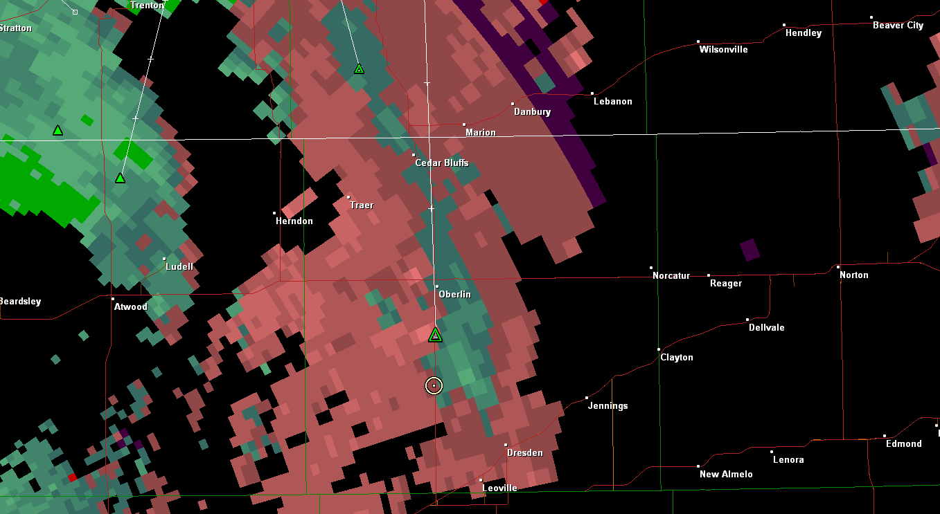
storm relative velocity showing weak broad rotation by the green in the middle surrounded by the pink coloring

Total miles driven: 827
largest hail: nickel

No comments:
Post a Comment