Most of my closest friends and family already know this news, but I thought I would make an official post here on my blog. I have decided to try and start my own storm chasing tour company!! I'm going to offer the group tours in a van, and also individual guided tours in the customer's car or my car. It's something that I have thought about doing for years now. I feel like I finally have enough experience to be able to offer a good tour to my customers. Of course, each time I go out is another chance to learn something new from Mother Nature, so I know I will continue to learn more and more as I go out.
I'm not sure what to expect out of the company, especially at first until my name gets out there more. I'm just hoping it's something that I will be at least moderately successful and at the very least allow me to continue doing what I love, and that's to chase storms!!
Here is the address for the new site. Please feel free to leave me comments about the site, and if you or anyone is interested in any of the tours let me know. Also, pass on the address to anyone you feel might want to find out more about the tours!!
www.greatplainstornadotours.com
you can email me at the following adresses: greatplainstornadotours@yahoo.com or Jeremy@greatplainstornadotours.com
Thursday, December 22, 2011
Thursday, September 1, 2011
Lightning pics
I'm posting some lightning pics mainly from a storm that moved through right about sunset on the 6th of August. Lightning photography is one of my favorite things to do, but this year it seems like either I have been too busy driving on a chase to get pics or the storms that have moved through when I have been home in Omaha have been in the middle of the night or didn't have very good cloud to ground lightning. The first series of pics again had mainly cloud to cloud lightning which still looked pretty cool with the line coming in. After the storm had passed by my house, it seemed to intensify with the cloud to ground lightning strikes. I should have gone out and gotten a better vantage point to look east but instead stayed in my driveway. A new set of storms formed to the southwest of town later that night and I tried to get some good shots from my back deck, but our stupid trees in our backyard are getting taller and taller!!

storm moving into town from the northwest


little bit of a shelf cloud coming into view


next couple of pics are from front driveway after first storm passed

should have gone to a better spot to look east over the city

2nd storms that formed west/southwest of town


The shot below was the lone good shot I got of a high based tstorm that moved through town on the night of the 23rd of August. The lightning with this, although not frequent, was very impressive. It had very sharp bolts that seemed to hit the Earth every time and then would make that loud boom of thunder. I barely missed 2-3 other good bolts with camera before coming inside after I no longer felt safe!

Saturday, July 30, 2011
7/26/11 First July chase!
Today was a day of firsts for me. It was my first chase in July, my first tornado this season, and my first tornado in South Dakota. It had been a month since I had last gone out chasing. I normally consider my chase season done at the end of June. That's when I stop trying to plan ahead for vacation anyways. The storm pattern moves north into South Dakota, North Dakota, and Montana, and it has been a pretty active month of July this year. However, I don't want to and financially can't continue to chase that far on what usually are marginal chase setups. This time of year there are more strong wind events and hail than tornadoes.
This day however showed one of the better setups in the past month. I was desperate to get out one more time, so I decided what the hell, I will go out chasing! I left Omaha about 945 in the morning, and made it up to north central S. Dakota about 430. I actually ended up in my hometown of Gettysburg waiting for initiation. I stopped by home and visited with mom for a bit, but within half an hour there was a tornado watch issued and storms were starting to form!
There were two initial cells, one southwest of Gettysburg and another northwest of Gettysburg. The cell to the southwest exploded more rapidly and as I watched it, it showed up to 3" hail on radar. The storm to my north however just kind of pulsed and never really got going at first. I was in a perfect position of being able to go after one storm and not be too far away from the other one. So I went after the first storm to my southwest. However, as I headed towards it, it weakened and by the time I intercepted it near Agar, there was only heavy rain and small hail. Also, other storms had formed to its south near Pierre that were now merging with it forming the dreaded line. I was already beginning to regret my decision to chase 7 hours from home.
I sat there as the storm moved onto the east and the storm to my north did nothing. I was treated to a cool double rainbow though and for a while an intense swirl in the clouds on the back of the storm that lasted for several minutes.
The line of storms now moving south of Gettysburg strengthened again and the storm to the north still didn't look that great on radar. However, I was getting a good look at the storm visually and it seemed like it was doing pretty good. I had to head back north a bit on Hwy 83 anyways if I wanted to go east on 212. I got to the intersection of 83/212 and decided that I would go for the storm to my north since it was by itself still. Also even though the storm wasn't that mature I could see it's base from about 15 miles away and it already had a lowering.
I approached the storm from the south as it tried to form a few wall clouds. It was in the perfect spot road network wise as well as it was right near the Hwy 20 intersection that went east and the storm was moving east as well. I would be able to follow along just to its south. It finally had a warning with it and was really looking impressive on radar. Also a large, slowly rotating wall cloud developed with it. I was sure this was going to make a large tornado!
I stopped once to get pics of the wall cloud and was right on the edge of the precip and gust front of the storm. The rotation in the clouds above me was impressive. However, I soon noticed that the wall cloud looked like it was beginning to be undercut by the cold outflow of the storm. The clouds were a bit choppy looking.
I went on ahead to the east stopping one more time just west of Hoven. I looked up almost directly above me and suddenly a small white funnel formed!! It was spinning pretty good and slowly dropped lower to the ground. I snapped some pics but didn't get any video. I realized though there was no tornado warning for the storm and it was right near the town of Hoven. I thought about trying to call the NWS, but didn't have their number so I thought it would be quicker to call 911.
I gave my report and location to the operator who had me hold while she called the sheriff. He was out spotting too and was north of town about 2 miles. He said he couldn't see anything from where he was at. I told them it wasn't a large funnel and wasn't on the ground. Right about that time though, a very intense dust whirl formed in the field in front of me, less than a quarter mile away!! I had my window open and was pretty sure I could hear the tornado!! I was caught without my video camera recording and while still on the phone tried to get some pics which turned out ok. I told the operator and sheriff what I just saw again. About this time another funnel formed above me a little further to the east. I also started to get blasted with rain and the RFD winds. The operator told me that the sheriff would call me back shortly.
I headed east on Hwy 20 towards Hoven. Suddenly, a fairly large debris cloud showed up in town!!! I could see what looked like part of a roof and other debris swirling around. This last about 45 seconds and disappeared. I drove into town and saw some damage including the business that lost its roof. The sheriff called me at this point and I told him what I saw including the tornado just going through town. There was a tornado warning out for the storm now, including text of my reportm, but when I drove through town not more than a minute after the tornado went through there were no sirens going off.
I headed on south a bit to the next east/west highway, but there was construction going on and the road was only one lane with a pilot car. I had to wait about 10 minutes and the storm moved on. It did become weaker though and didn't produce anymore tornadoes. I chased after a bit longer hoping to get some good shots but it didn't work out and I headed home with a long 7 hour drive in front of me. I arrived home exhausted at 345 in the morning after a 1,075 mile round trip. I was happy I went though finally catching my first tornado of the season.
I've been in contact with the sheriff and sent him by video and pics. Apparently the local paper is going to use my pics. I know, big time huh?! I also sent my pics and video the NWS in Aberdeen. I'm not sure if they were going to do a damage survey until they saw my media. But the storm survey that came out seemed to point to the fact they used it! The tornado was rated an EF-0 with winds of 80 mph or so.
text of the tornado warning issued:
TORNADO WARNING
NATIONAL WEATHER SERVICE ABERDEEN SD
703 PM CDT TUE JUL 26 2011
THE NATIONAL WEATHER SERVICE IN ABERDEEN HAS ISSUED A
* TORNADO WARNING FOR...
SOUTHWESTERN EDMUNDS COUNTY IN NORTH CENTRAL SOUTH DAKOTA...
NORTHEASTERN POTTER COUNTY IN NORTH CENTRAL SOUTH DAKOTA...
SOUTHEASTERN WALWORTH COUNTY IN NORTH CENTRAL SOUTH DAKOTA...
* UNTIL 730 PM CDT
* AT 658 PM CDT...TRAINED WEATHER SPOTTERS REPORTED A FUNNEL CLOUD
NEAR HOVEN...OR 17 MILES SOUTHEAST OF SELBY. A TORNADO MAY DEVELOP
AT ANY TIME! DOPPLER RADAR SHOWED THIS TORNADIC STORM MOVING EAST
AT 25 MPH.
text of the damage survey:
POTTER COUNTY EF-0 TORNADO...
MEDIA AND TRAINED SPOTTER INFORMATION CONFIRMED A BRIEF TORNADO
TOUCHDOWN ON THE NORTHSIDE OF HOVEN IN EXTREME NORTHERN POTTER
COUNTY. ONE BUSINESS SUFFERED ROOF DAMAGE WITH REPORTS OF TREE
DAMAGE TO THE NORTH OF TOWN. INDICATIONS ARE THAT THIS TORNADO WAS
ON THE GROUND FOR ONLY A BLOCK OR TWO BEFORE LIFTING BACK INTO THE
PARENT THUNDERSTORM. INSPECTION OF THE DAMAGE IS INDICATIVE OF AN
EF-0 TORNADO WITH WINDS ESTIMATED BETWEEN 70 AND 80 MPH.
Outlooks issued for this day:

800 am- moderate risk

800 am tornado probs- 10% hatched area showing strong tornadoes possible

800 am severe hail probs

800 am severe wind probs

1130 am outlook- moderate risk still in place

1130 am tornado probs

1130 am severe wind probs

1130 am severe hail probs

first storm of the day southwest of Gettysburg

I love to take these closeups of storms showing the boiling sky

backside of storm east of Agar now with double rainbow

storm strengthening to my north near Akaska

I'm about 15 miles away from the storm now. Storm is growing but already has a small area of lowering developing!

closer now to the storm and can see a wall cloud developing!

closer now to the storm just west of Hwy 83 and Hwy 20

storm looks like it was starting to form an RFD notch and inflow tail

new wall cloud trying to form. area to the left was intense area of rapidly rising scud forming

tried to get a better structure shot. I need a wide angle lens!

still a small area of intense rising motion just to the right of center

wall cloud getting larger

i had driven for about 5 minutes or so east on Hwy 20 and got out to take some pics. this was the large wall cloud I was treated too!! I thought for sure at this point there was going to be a big tornado that would form. I was already thinking Bowdle! The wall cloud wasn't rotating too rapidly yet, though you definitely see rotation

gust front of storm directly above me

directly above me were these intense roll clouds! i had to watch them to make sure they didn't spin up something that would reach towards the ground

another shot of these intense spinning areas

this was just west of Hoven now near the intersection of Hwy 20 and 47. I looked up above me and suddenly this small white funnel formed directly above me!

another shot of the white funnel extending down a little further

again. it was around this point that I realized there was no tornado warning for this storm and it was heading towards a town so I called 911

shot of the intense dust whirl from the tornado on the ground in the field across from me

another shot of the tornado continuing across the field. i was relaying all this info the 911 operator

new funnel that formed just a bit further east of me. I was still on the phone with 911 at this point telling them about the new funnel forming heading towards Hoven still.

shot of the tornado going though Hoven!!

still on the ground! you could see a part of a roof swirling around in the air and other debris!

one more shot

part of roof missing! i'm guessing this was the roof I saw flying around in the air
some radar grabs:

640 pm- storm rapidly becoming severe just north of me(I'm the white circle). the original severe storm I was on near Agar is to my south

720 pm- storm moving east of Hoven now with good inflow notch on front side. a new tornado warning was about to be issued to the east of the old purple box

720 pm- storm relative velocity image showing well defined couplet(red next to green in center of image). never did see confirmation of tornado on the ground at this point
video of the tornado going through Hoven
link to youtube video(in HD quality):
HD Hoven video on youtube
route taken. I only am showing the part of the chase in S. Dakota

total miles: 1076
tornadoes: 1 (YES!!)
largest hail: .75"
strongest wind: est. 50-55 mph
This day however showed one of the better setups in the past month. I was desperate to get out one more time, so I decided what the hell, I will go out chasing! I left Omaha about 945 in the morning, and made it up to north central S. Dakota about 430. I actually ended up in my hometown of Gettysburg waiting for initiation. I stopped by home and visited with mom for a bit, but within half an hour there was a tornado watch issued and storms were starting to form!
There were two initial cells, one southwest of Gettysburg and another northwest of Gettysburg. The cell to the southwest exploded more rapidly and as I watched it, it showed up to 3" hail on radar. The storm to my north however just kind of pulsed and never really got going at first. I was in a perfect position of being able to go after one storm and not be too far away from the other one. So I went after the first storm to my southwest. However, as I headed towards it, it weakened and by the time I intercepted it near Agar, there was only heavy rain and small hail. Also, other storms had formed to its south near Pierre that were now merging with it forming the dreaded line. I was already beginning to regret my decision to chase 7 hours from home.
I sat there as the storm moved onto the east and the storm to my north did nothing. I was treated to a cool double rainbow though and for a while an intense swirl in the clouds on the back of the storm that lasted for several minutes.
The line of storms now moving south of Gettysburg strengthened again and the storm to the north still didn't look that great on radar. However, I was getting a good look at the storm visually and it seemed like it was doing pretty good. I had to head back north a bit on Hwy 83 anyways if I wanted to go east on 212. I got to the intersection of 83/212 and decided that I would go for the storm to my north since it was by itself still. Also even though the storm wasn't that mature I could see it's base from about 15 miles away and it already had a lowering.
I approached the storm from the south as it tried to form a few wall clouds. It was in the perfect spot road network wise as well as it was right near the Hwy 20 intersection that went east and the storm was moving east as well. I would be able to follow along just to its south. It finally had a warning with it and was really looking impressive on radar. Also a large, slowly rotating wall cloud developed with it. I was sure this was going to make a large tornado!
I stopped once to get pics of the wall cloud and was right on the edge of the precip and gust front of the storm. The rotation in the clouds above me was impressive. However, I soon noticed that the wall cloud looked like it was beginning to be undercut by the cold outflow of the storm. The clouds were a bit choppy looking.
I went on ahead to the east stopping one more time just west of Hoven. I looked up almost directly above me and suddenly a small white funnel formed!! It was spinning pretty good and slowly dropped lower to the ground. I snapped some pics but didn't get any video. I realized though there was no tornado warning for the storm and it was right near the town of Hoven. I thought about trying to call the NWS, but didn't have their number so I thought it would be quicker to call 911.
I gave my report and location to the operator who had me hold while she called the sheriff. He was out spotting too and was north of town about 2 miles. He said he couldn't see anything from where he was at. I told them it wasn't a large funnel and wasn't on the ground. Right about that time though, a very intense dust whirl formed in the field in front of me, less than a quarter mile away!! I had my window open and was pretty sure I could hear the tornado!! I was caught without my video camera recording and while still on the phone tried to get some pics which turned out ok. I told the operator and sheriff what I just saw again. About this time another funnel formed above me a little further to the east. I also started to get blasted with rain and the RFD winds. The operator told me that the sheriff would call me back shortly.
I headed east on Hwy 20 towards Hoven. Suddenly, a fairly large debris cloud showed up in town!!! I could see what looked like part of a roof and other debris swirling around. This last about 45 seconds and disappeared. I drove into town and saw some damage including the business that lost its roof. The sheriff called me at this point and I told him what I saw including the tornado just going through town. There was a tornado warning out for the storm now, including text of my reportm, but when I drove through town not more than a minute after the tornado went through there were no sirens going off.
I headed on south a bit to the next east/west highway, but there was construction going on and the road was only one lane with a pilot car. I had to wait about 10 minutes and the storm moved on. It did become weaker though and didn't produce anymore tornadoes. I chased after a bit longer hoping to get some good shots but it didn't work out and I headed home with a long 7 hour drive in front of me. I arrived home exhausted at 345 in the morning after a 1,075 mile round trip. I was happy I went though finally catching my first tornado of the season.
I've been in contact with the sheriff and sent him by video and pics. Apparently the local paper is going to use my pics. I know, big time huh?! I also sent my pics and video the NWS in Aberdeen. I'm not sure if they were going to do a damage survey until they saw my media. But the storm survey that came out seemed to point to the fact they used it! The tornado was rated an EF-0 with winds of 80 mph or so.
text of the tornado warning issued:
TORNADO WARNING
NATIONAL WEATHER SERVICE ABERDEEN SD
703 PM CDT TUE JUL 26 2011
THE NATIONAL WEATHER SERVICE IN ABERDEEN HAS ISSUED A
* TORNADO WARNING FOR...
SOUTHWESTERN EDMUNDS COUNTY IN NORTH CENTRAL SOUTH DAKOTA...
NORTHEASTERN POTTER COUNTY IN NORTH CENTRAL SOUTH DAKOTA...
SOUTHEASTERN WALWORTH COUNTY IN NORTH CENTRAL SOUTH DAKOTA...
* UNTIL 730 PM CDT
* AT 658 PM CDT...TRAINED WEATHER SPOTTERS REPORTED A FUNNEL CLOUD
NEAR HOVEN...OR 17 MILES SOUTHEAST OF SELBY. A TORNADO MAY DEVELOP
AT ANY TIME! DOPPLER RADAR SHOWED THIS TORNADIC STORM MOVING EAST
AT 25 MPH.
text of the damage survey:
POTTER COUNTY EF-0 TORNADO...
MEDIA AND TRAINED SPOTTER INFORMATION CONFIRMED A BRIEF TORNADO
TOUCHDOWN ON THE NORTHSIDE OF HOVEN IN EXTREME NORTHERN POTTER
COUNTY. ONE BUSINESS SUFFERED ROOF DAMAGE WITH REPORTS OF TREE
DAMAGE TO THE NORTH OF TOWN. INDICATIONS ARE THAT THIS TORNADO WAS
ON THE GROUND FOR ONLY A BLOCK OR TWO BEFORE LIFTING BACK INTO THE
PARENT THUNDERSTORM. INSPECTION OF THE DAMAGE IS INDICATIVE OF AN
EF-0 TORNADO WITH WINDS ESTIMATED BETWEEN 70 AND 80 MPH.
Outlooks issued for this day:

800 am- moderate risk

800 am tornado probs- 10% hatched area showing strong tornadoes possible

800 am severe hail probs

800 am severe wind probs

1130 am outlook- moderate risk still in place

1130 am tornado probs

1130 am severe wind probs

1130 am severe hail probs

first storm of the day southwest of Gettysburg

I love to take these closeups of storms showing the boiling sky

backside of storm east of Agar now with double rainbow

storm strengthening to my north near Akaska

I'm about 15 miles away from the storm now. Storm is growing but already has a small area of lowering developing!

closer now to the storm and can see a wall cloud developing!

closer now to the storm just west of Hwy 83 and Hwy 20

storm looks like it was starting to form an RFD notch and inflow tail

new wall cloud trying to form. area to the left was intense area of rapidly rising scud forming

tried to get a better structure shot. I need a wide angle lens!

still a small area of intense rising motion just to the right of center

wall cloud getting larger
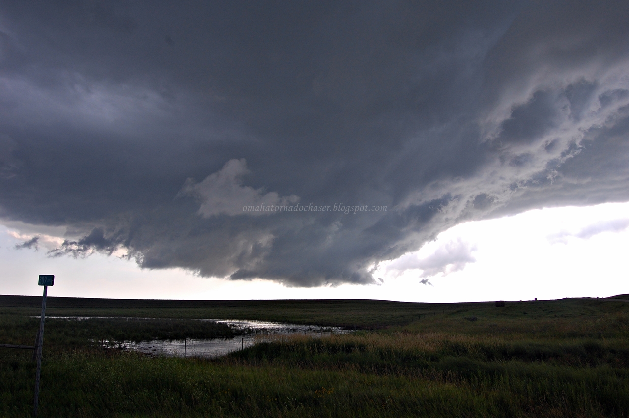
i had driven for about 5 minutes or so east on Hwy 20 and got out to take some pics. this was the large wall cloud I was treated too!! I thought for sure at this point there was going to be a big tornado that would form. I was already thinking Bowdle! The wall cloud wasn't rotating too rapidly yet, though you definitely see rotation

gust front of storm directly above me

directly above me were these intense roll clouds! i had to watch them to make sure they didn't spin up something that would reach towards the ground

another shot of these intense spinning areas

this was just west of Hoven now near the intersection of Hwy 20 and 47. I looked up above me and suddenly this small white funnel formed directly above me!

another shot of the white funnel extending down a little further

again. it was around this point that I realized there was no tornado warning for this storm and it was heading towards a town so I called 911

shot of the intense dust whirl from the tornado on the ground in the field across from me

another shot of the tornado continuing across the field. i was relaying all this info the 911 operator

new funnel that formed just a bit further east of me. I was still on the phone with 911 at this point telling them about the new funnel forming heading towards Hoven still.

shot of the tornado going though Hoven!!
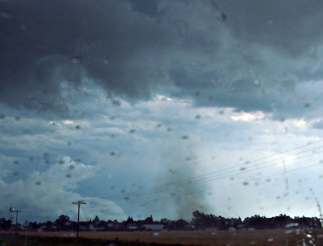
still on the ground! you could see a part of a roof swirling around in the air and other debris!

one more shot

part of roof missing! i'm guessing this was the roof I saw flying around in the air
some radar grabs:

640 pm- storm rapidly becoming severe just north of me(I'm the white circle). the original severe storm I was on near Agar is to my south

720 pm- storm moving east of Hoven now with good inflow notch on front side. a new tornado warning was about to be issued to the east of the old purple box

720 pm- storm relative velocity image showing well defined couplet(red next to green in center of image). never did see confirmation of tornado on the ground at this point
video of the tornado going through Hoven
link to youtube video(in HD quality):
HD Hoven video on youtube
route taken. I only am showing the part of the chase in S. Dakota

total miles: 1076
tornadoes: 1 (YES!!)
largest hail: .75"
strongest wind: est. 50-55 mph
Subscribe to:
Comments (Atom)
