Friday, July 30, 2010

U.S. record sized hail and fatal Montana tornado

There were two extreme weather events within a couple of days of each other this last week of July. First off, a huge supercell thunderstorm formed in central south dakota on the afternoon of july 23, 2010. This storm moved into the town of vivian, south dakota where it dropped the record hailstone. vivian is 30 miles south of pierre on I-90 and i've driven by vivian numerous times in my years of living in south dakota. the record stone ended up being 8" in diameter, and 18.625" in circumference! it also weighed almost 2 pounds. as a comparison, a volleyball is only about a 1/2" bigger in diameter, but is much bigger in circumference due to it being perfectly spherical. The previous record was for a 7" diameter stone that fell several years ago in Aurora, Nebraska, and that stone still has the record for circumference at 18.75"!! one home had 18 holes punched through it's roof, with a few of the holes coming through the ceiling, so the stones were laying on the floor inside the house! the record setting stone was actually larger, but it wasn't found until an hour and a half after the storm ended. also the person that found the stone, lost power during the storm so his freezer wasn't working for several more hours!! it is believed that it was possible for some of the stones to be as large as 10 or 11 inches!! many 6" or larger stones were also found. for those who don't know how hail forms, intense updrafts in a thunderstorm are needed to push the hail higher and higher so it can continue to freeze and add more ice. meteorologists estimate that the updrafts in this storm had to be 160-180 mph in order to hold hailstones this size!!!

here's some links and pics from this storm:

http://www.crh.noaa.gov/abr/?n=stormdamagetemplate

http://www.mitchellrepublic.com/event/article/id/45038/


divot left in ground from stone


Then on july 26th, an EF-3 tornado touched down in northeast montana, killing 2 people and injuring 1 other. Tornadoes in Montana are fairly rare, but are more common in july. However, especially strong tornadoes are very uncommon. This was only the 3rd EF-3 tornado ever recorded in the state. The tornado was in a very sparsely populated area of the state, but it did hit a large ranch, where the fatalities occurred. i've included the damage survey and the cnn story with a video below:

http://www.cnn.com/2010/US/07/27/montana.tornado.deaths/?hpt=T2


http://www.wrh.noaa.gov/ggw/PRSheridan_Tornado.pdf

Saturday, July 17, 2010

Omaha wind storm 7/14/10

first off, i wanted to post a thought. i noticed in my last post that i said severe weather season would be done more than likely. that was back in june. i wanted to clarify, especially since there has been a lot of severe weather throughout july. i meant the threat for widespread tornadoes was basically done, especially in nebraska and neighboring areas of iowa and kansas. the severe weather can still continue anywhere, especially to the north of me in south dakota, north dakota, minnesota, and even montana. i guess yesterday, 2 people died from a tornado out in the prairies of montana.

we had our worst wind storm in a couple of years blow through Omaha between 7 and 730 pm. winds were measured between 65-80 mph across most of the county, especially the western half, west of interstate 680. it was the hottest day of the summer and combined with oppressive humidity made it feel like 115 degrees outside, even though the air temp was "only" 97 degrees. the storms developed west and northwest of town and slowly strengthened until they started producing 70 mph winds about 20 miles west of town. i went out west of town down to 226th and maple. we live near 156th and maple. i left too late to get a lot of good pictures or video, and actually it was so muggy out that my lens on my camera immediately fogged up anyways the second i stepped out of the car! i was not that impressed with the structure of the storm compared to some others i've seen. normally storms that are this strong have a really nicely developed shelf cloud. as i was watching the storm come in, it was kicking up a lot of dust out in the fields several miles away. i was watching the radar, and the storm started to bow out as it was getting closer, signaling the winds were getting stronger. when the winds started to pick up at my location, i got back in the car and tried to race back home down maple street. i hit several stoplights of course, so i never really got back in front of the storm all the way. as i was driving, leaves and small branches were blowing across the road and one big gust of wind actually pushed my car over quite a bit. i made it home to the sirens blaring, which they activate if winds are forecast to be over 75 mph! i watched the storm out our windows and after the inital surge of winds that were maybe 50 mph, the winds let up. i thought this was it, but after another 4-5 minutes or so, the main damaging winds hit. winds at my place were near 70 mph i would say. my weather station on our roof blanked out, and still isn't working, so i don't know exactly what the strongest winds were. as i watched out our back door, i could see the neighbors house losing its shingles. a few small branches broke, but i was surprised how few branches there were on the ground. back west along maple street, there were a couple of large trees that blew over a few minutes after i had passed. the storm had seemed to let up a little at our house, when suddenly the power went out. it went out for not more than 5 minutes when it came back on. however, it only stayed on for another 5 minutes or so again, before going out again. this time it stayed off until after 11 pm! it was odd to notice where the power went out too. literally if you went 2 blocks north, east, or west there was power. however if you headed south, everyone was without power for quite a ways. i believe oppd said at one point there were 43, 000 people without power in its district, with 27,000 of those here in omaha. we went over to sarah's sister's house since they still had power. the backside of the storm was amazing! first there were intense cg lightning strikes. i was inside, and after hearing about the 4th or 5th loud boom, i went out to try and capture one on camera. of course the lightning really let up then. the sun then started to come out and created almost a full double rainbow. it was awesome to see, but i wasn't quite as excited as this guy in this video!! seriously watch this video, and try not to bust a gut laughing:

http://www.wimp.com/lovesrainbows/

anyways, the lighting from the sun after the storm was also awesome. here's some pics below.

here's a link to the wind gusts across the area:
http://www.crh.noaa.gov/news/display_cmsstory.php?wfo=oax&storyid=55153&source=0


Wednesday, July 7, 2010

Southeast South Dakota 6/26/10

this will possibly be the last chase of the 2010 season. not because i can't go anymore, but because the actual season is probably done. the weather pattern now through september will mainly not be conducive for severe weather. in september there can be a second season, so there might be a chance or two to go out again then. today was another moderate risk day chase. i had missed a day the week before that looked like it could be really good, but luckily for me nothing huge happened. the chase before this one in northern kansas also showed potential for a big day, but was basically a bust. so i was hoping today wouldn't continue the streak of "bad" moderate risk days. i left kind of last minute around 2 pm, as i wasn't even going to go out today until i saw the forecasts more closely. my target was southeast south dakota. here a warm front was forecast to set off storms in an extremely unstable environment with some of the highest amounts of energy in the atmosphere that there's been all year!

outlook issued at 1130 am

tornado risk issued at 1130 am. this was a higher risk than was issued for minnesota outbreak)

hail risk issued at 1130 am

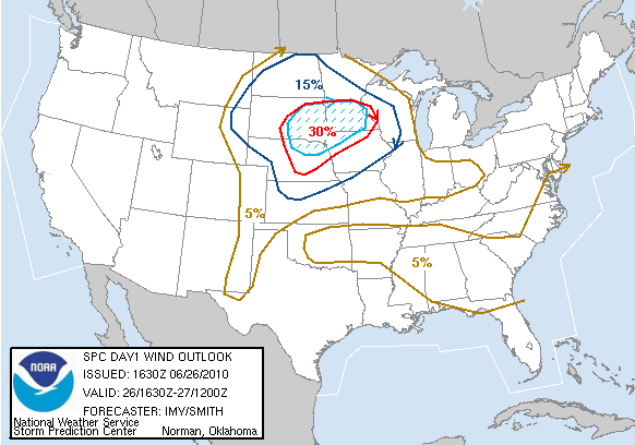
severe wind outlook issued at 1130 am

outlook issued at 3 pm. notice the moderate risk expanded into nebraska

high risk tornado area expanded!!

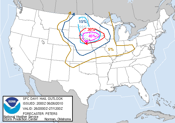
hail risk area at 3 pm

severe wind area expanded as well!

map of extreme instability

again

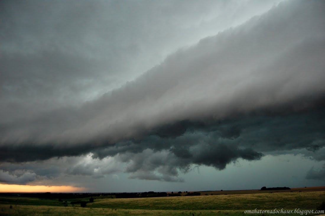
i went up I-29 and into southeast south dakota. a storm developed and quickly became severe near parkston, south dakota moving east. i went far enough north on I-29 and then headed west towards the storm. i could see the tops of the storm from more than 60 miles away!! the storm went tornado warned as i was about 25 miles away! i thought i was timing this perfect. i continued west having to take some gravel roads to get into position. as i approached the storm, i could see its base, and there was a very low hanging cloud underneat the storm. i couldn't tell if it was rotating or just scud. then as i got within 10 miles or so, the storm began to look less impressive and there was no longer anything hanging under the base of the storm.

pic of storm from 50+ miles away. the tops of the storm were estimated over 60, 000 feet tall!

getting closer

the base of the storm as i approached. notice the lowerings underneath the storm!

getting closer, storm still looks good

storm looking less impressive

i followed the storm back to the east, staying along to the south of the storm. it never looked real impressive tornadically, but it had some reports of large hail and winds of 70 mph as it moved into sioux falls, south dakota. meanwhile storms began filling in everywhere. this is bad for tornado chances, and i was beginning to doubt this day. i gave up on this storm and headed back south down I-90. there were a couple of more severe storms near yankton moving northeast towards my direction. i stopped in beresford, south dakota and let these storms overtake me. they were warned for quarter size hail or larger, and i thought i would like to get some more dents!! the hail never got larger than marbles or so, though. the line of storms continued to backbuild down to the south, and since there was nothing else going on i followed them into western iowa to see if i could get lucky. these storms did nothing else either and so i headed home, tired and disappointed!

some more pics from the chase:

storm heading towards sioux falls

one of the cooler things i've seen chasing! a "hole" in the middle of the storm

again, closer. this lasted for more than 5 minutes!

facing storm to the north towards sioux falls

new storms near lennox, sd

again


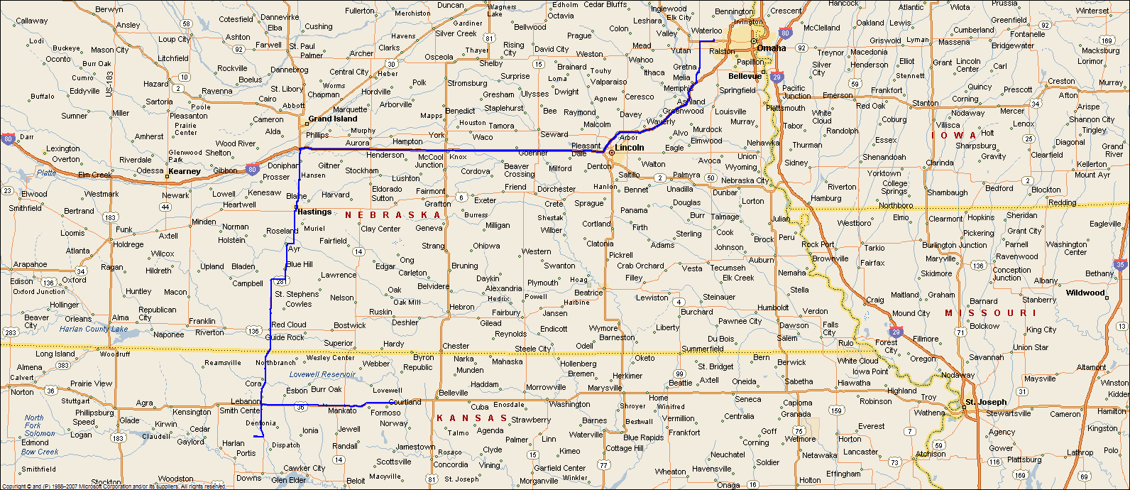
partial map of route:

Monday, July 5, 2010

north central kansas 06/20/10

this was my first chase after my epic tornado day just 3 days earlier. another huge moderate risk area was forecast, and the percentage odds of tornadoes were almost as high as the day in minnesota. with such a large target area it was hard to pinpoint a place to go. the days leading up to this event, i thought i would be heading into northeast nebraska/extreme northwest iowa. the warm front that was going to set off the storms though, didnt make it that far north. the day of the chase my friend casey and i went west along I-80 and then south into north central kansas. storms had fired in northwest kansas by the time we left, and it was still cloudy in omaha and had rained off and on most of the day pretty much killing the chance of anything good happening close to home. here is some of the forecast risk graphics:


first risk outlook issued just after midnight the night before

risk area issued at 1130 am that day

hail probabilities, notice the huge "hatched" are meaning a high risk of very large hail

tornado chances showing a fairly high risk of tornadoes

the chances were also very high for large area to get a line of extreme damaging winds over 80 mph, including the possibility of a derecho developing which is a long lived, large line of damaging winds

i was a little surprised that the risk area stayed as far north as it did, for as long as it did. like i mentioned clouds and rain ruined the really strong instability that was supposed to develop. anyways casey and i continued on south and west of omaha, finally arriving in north central kansas on hwy 181 west of a town called dentonia. the storms that were moving in from the west were only severe warned for 60 mph winds. we found a gravel road to head west on from the hwy that allowed us to get a good view of the incoming line of storms. it was a fairly cool looking storm but nothing outstanding.


the line began to come over us and we didn't want to stay on gravel in the rain so we got back to the hwy and headed back north. i knew we would be driving in the storm as it moved across us to the east. the storm had fairly strong winds and very heavy rain. suddenly after a few minutes on the highway, the nws put out a tornado warning for the storm we were on! the storm had really bowed out now and on the northern end of the line was a notch where tornadoes can form. the winds which had been howling in from the west, switched to the north and then east and then south as we were driving. about this same time a report came out of a tornado on the ground right near our location.

radar grab of the line of storms right after the tornado warning came out. we're located at the white circle inside the purple box under the red lines! the tornado would be in that notch in the bright colors to the left of us!

a little bit later as we are heading east, the tornadic part of the storm is now to our northwest behind us.

it's very possible we were right underneath the tornado or at very least very close to where it developed! we never saw a tornado, but the reports of the tornado on the ground were rain wrapped tornadoes, so in other words very hard to see. we continued to head east on the highway trying to stay in front of the storm. we would stop every 15-30 minutes to try and take pics, but it always seemed like the storm would be right on top of us again! eventually we ended up in marysville, ks and headed north towards home from there. since the storms were moving east and we headed north the line overtook us. the lightning was some of the best lightning i have ever seen. unfortunately of course this was in the middle of the rain so i couldn't stop and get any good pics. overall, this wasn't a horrible chase, and was actually kind of crazy for awhile, but i was disappointed with the overall severe weather that developed.
some pics from the rest of the chase:


maps of the route(minus the very end on the way home)