We drove home from Kansas City leaving late morning and arriving in Omaha by 230 pm. One thing that worried me was the clouds I drove through all the way home, which was through the target area. The clearing line though was slowly moving north but this held the warm front further south into southeast Nebraska. I left Omaha with an initial target of Beatrice. By the time I made it down there it was warm and sunny and incredibly humid. I was watching the different parameters for severe weather and they were off the chart!! Now if only something could pop. I was noticing one huge negative though. The mid level temps were really warm which could hinder storms from forming.
I sat around Beatrice for about an hour seeing nothing but blue skies and the mid level temps not improving. I finally accepted the fact that nothing was going to form in this potentially explosive environment. There was a line of storms with strong winds that was racing east and southeast from central nebraska though so I figured I would go intercept those. I headed north to northwest of Lincoln near Dwight and Ulysses Nebraska. The storms here were warned for strong winds and I was on the very southern end of the line. They became stronger though and showed potential for large hail along with the winds. I put myself in place for intercept and right about then a tornado warning came out for just to the south of me. It didn't look that great on radar so I stayed where I was. I was hit with probably nickel sized hail or so and winds that were 60-65 mph. The storm moved past me, but I caught back up with it again and this time ran into some larger hail up to quarters that put a few more dents in the car! After this I headed home, still with an 0-fer the season.
I was glad to get out again for a surprise chase. This was another frustrating weather day where seeming everything was there for a possibly huge tornado outbreak, but one ingredient was missing, a breakable cap. I was sure this would be the last chase of the season as we were now heading into July.

800 am outlook- large moderate risk right over eastern Nebraska

800 am tornado probs- scary chances of strong tornadoes in the red hatched area!

800 am wind probs

800 am hail probs showing very large hail for significant hail possible

1130 am- severe weather probs. still large moderate risk area!

1130 am tornado probs- still a large 15% hatched area. very impressive!!
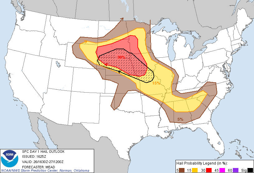
1130 am severe hail probs- large hatched area showing extreme hail possible

1130 am severe wind probs

3 pm outlook- note moderate risk downgraded to slight risk

3 pm tornado outlook- probs down to 10% but still hatched area showing strong tornadoes possible

3 pm hail probs

3 pm severe wind probs
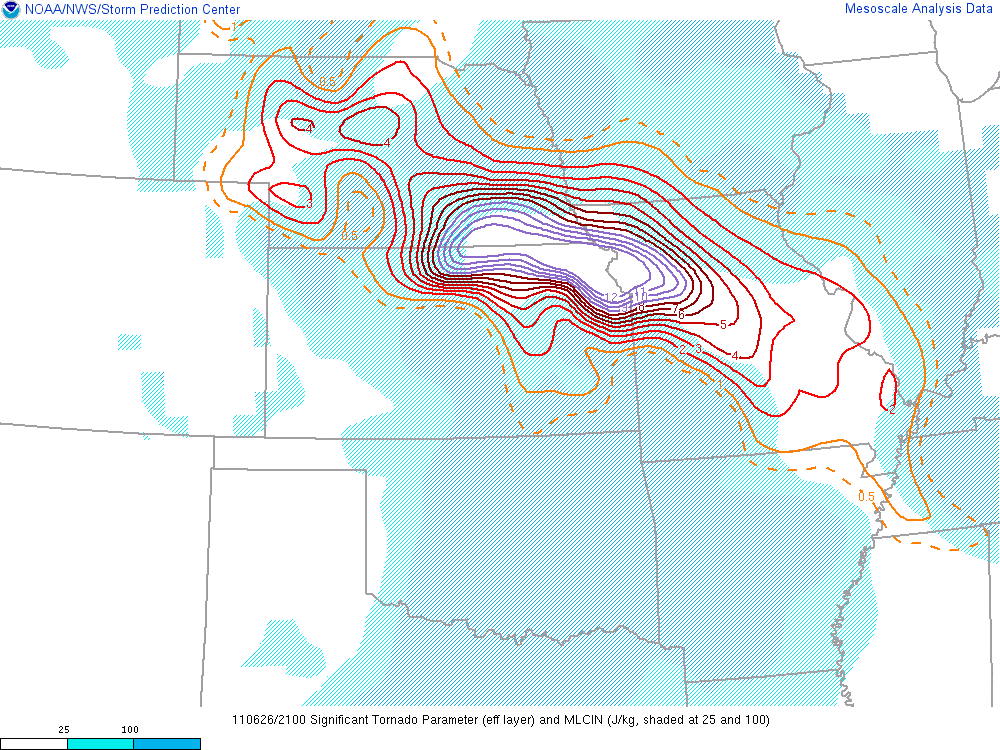
5 pm significant tornado index. this index is a combination of different indices to give a scale of where the best chance of significant tornadoes could happen. It's very rare to see the numbers this high. I believe actually the scale might be maxed out at 12!

530 pm significant tornado index

530 pm supercell composite index- another gauge of the atmosphere showing the best area for development of supercell thunderstorms. Again this number was extremely high
Below are pics I took on my way home. I was behind the line of storms and the anvil overhead with mamatus clouds made for a brilliant sunset!


total miles: 260
tornadoes: 0
largest hail: 1"
strongest wind: est. 65 mph

No comments:
Post a Comment