Saturday, May 1, 2010

4/29/10 Southeastern Nebraska

I went on a pretty fun chase today in southeast Nebraska. A powerful storm had been forecasted for days to move out onto the plains. Unfortunately, there wasn't going to be a lot of moisture so the cloud bases were going to be pretty high, and also the winds weren't going to be backed to increase the near surface shear needed for tornadoes. with the lower moisture, i figured i would still go out and hopefully get some good storm structure pictures. i left omaha around 415 after the first storms started firing down in north central kansas. on the way to southeast of lincoln, the severe storms moved out of kansas and weakened. the winds had veered to the southwest and caused the dewpoints to drop all the way down to the low to mid 40's.


pics of what was left of the first storms, taken east of Adams, NE

i was seriously planning on heading southeast towards nebraska city or in that area, bc there the moisture was way better with dewpoints in the mid to upper 50s. i messed around taking some pictures and there were more storms that had developed in nearly the same spot as the first storms in northern kansas. these storms were strengthening and heading towards the border. nothing else was looking great so i decided to head south of beatrice and meet these storms. i took a couple more pics of the high based storms developing.


the storms continued to strengthen down in kansas as the moved north. one cell became tornado warned and soon a report of a tornado on the ground was reported! i ended up south of beatrice and met the storms, but unfortunately they had weakened again in the lower moisture and was no longer tornado warned. the storm still had some good rotation, and i took some good video of scud forming out of mid air and rising into the storm as it tried one more time to form a wall cloud. below are a couple of pics of this happening near odell, nebraska.


again more storms had fired in the same spot in kansas and were moving north towards southern nebraska, this time a little further west. at first i figured these storms would die as well as they came closer, but they were looking really good on radar and were tornado warned as well. so after briefly heading north towards beatrice to start heading home, i turned around and thought i would try to meet the storms again and at least get some more pics before dark. as i headed back west on hwy 8 towards odell, i looked up and saw these amazing mamatus clouds.


the storm was still looking really good as it now headed towards fairbury, ne. i contunued to head west on hwy 8, stopping at little county roads to get pictures of the amazing shelf cloud that was coming into view. the anvil of the storm had amazing lightning shooting out of it and i was able to get one shot of it.


here are some pics of the shelf cloud coming into view


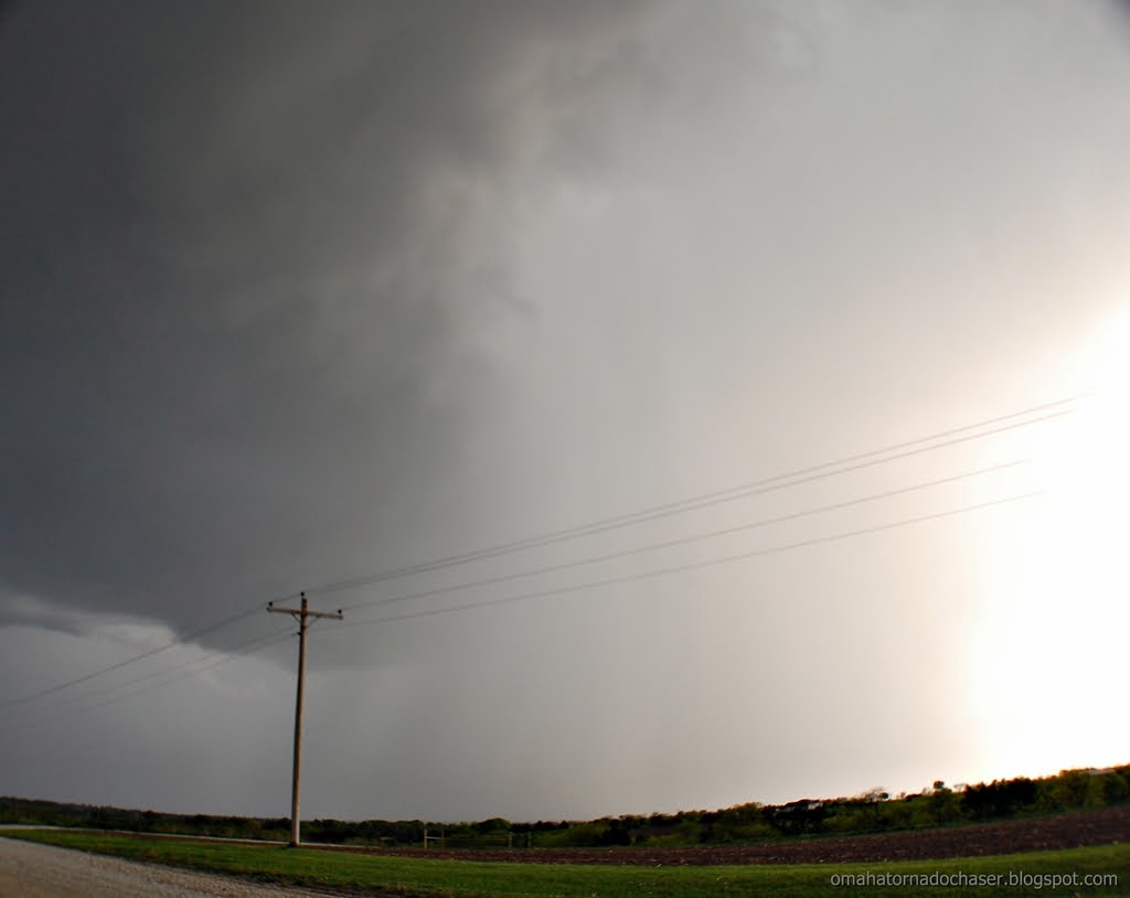
the last stop i made was just east of the town steele city. i couldn't see the town from where i was at but could hear the sirens blaring. the storms were moving at 50-55 mph, and suddenly the storm was basically on top of me just to my northwest. i hadn't been looking at the radar real closely, but looked at it now to see an amazing hook on the storm and it was still tornado warned. radar was also showing almost baseball sized hail!! the shelf cloud was bright grayish-white when compared to the dark storm clouds behind it. i had turned onto a gravel county road that was pretty muddy from the previous storms that had already passed through. i headed north about 1/4 to 1/2 mile. the storm was now passing directly to my north, and had some of the most intense motions i've ever seen! i could hear the wind coming and it became really windy at my spot. i was near some powerlines so i drove backwards back down the gravel road to the highway and headed back east on hwy 8 so i could head north towards beatrice. here are some pics of the storm from the gravel road. apparently there was a tornado that was on the ground at this point that was rated an EF-1. it took out a ton of powerpoles and knocked over a center pivot. looking at the map it was only about 4 miles from me!
the pics below show the storm crossing the road in front of me. on the last 3 pics you can see a lowering thats basically above the road. that might be the tornado?!


link to damage survey of tornado: http://www.crh.noaa.gov/news/display_cmsstory.php?wfo=oax&storyid=51691&source=2

as i headed back east on hwy 8 and then north towards beatrice, there were continued tornado warnings and report of a tornado on the ground near beatrice, but i haven't seen that confirmed. i stayed behind the storm and it eventually weakened a little. it was dark now so i headed towards home. on the way i stopped to take some lightning pics as there were storms all around me that had amazing lightning. the first spot i stopped was along the hwy on the shoulder. i got out of my car to set up my tripod. there was a house down a gravel road about 1/2 mile and i could hear a dog barking presumably at me. i ignored it at first but it sounded like he was getting closer! so i hopped back in the car and used my little tripod to rest sarah's camera and took some pics there. the clouds were moving so fast though they came out blurry. i also got out my new camera and was able to get one good pic before the rain started again.


as i headed north there was one more impressive storm that was going to cross in front of me. this storm would have been amazing to see in the daylight! it had a huge shelf cloud that was being backlit by constant lightning. this shelf cloud was huge and looked like it was basically on the ground!! i should have just gotten out and taken some pics with sarah's camera, but i wanted to take them with my camera. i pulled over onto the muddy shoulder, and had to try and set up my tripod and attach the camera, etc. then i went to take the pics and my camera wouldn't work!! by the time i got it figured out, the storm was on top of me and the wind was howling and it started raining. i was so mad!! the rest of the trip home was spent driving through pouring rain, and oddly enough areas of really dense fog, which was odd for how windy it was and how hard it was raining.
here's some images of the outlooks issued, the tornado watch issued, and the forecast hodographs which did show the low level shear really increasing after 7pm.


map of route driven

Saturday, April 24, 2010

4/23/10 Eastern Nebraska

I had another "disappointing" chase today, so to speak. Everything looked pretty good for several tornadoes, and even a couple a days prior the Storm Prediction Center was worried about a lot of tornadoes with some possibly strong. The day of the chase they backed down on their wording, but there was still a 10% chance of tornadoes, which is pretty darn good! i asked sarah to come along since it was going to be a close chase and this seemed like a pretty sure bet to see something cool. it's been pretty ironic though, everytime sarah has come with nothing has really happened! we left about 130 and headed west on the interstate past lincoln. there was a tornado watch issued for central and western nebraska and the storms were supposed to form along an arc from western to central to southeast nebraska and then move north. we went as far west as seward, nebraska and then waited. and waited, and waited...... at first the clouds were mushy looking, but finally they started to get bigger and taller. we looked back towards the east and thats where they were really starting to look good. so we started heading back towards omaha! i had several small computer issues today and that slowed me down a few times, how annoying! once the radar wasnt working, another time my internet quit, another time my gps mapping software quit. each time i had to restart the computer. we eventually ended up back on hwy 6 and 30 just north of elkhorn(only about 10 miles from home!) and waited for a small thundershower to move over us. the storm clouds were looking alot better, but didn't show much on the radar. finally a few more cells popped up southeast of lincoln and those at first didn't do much, but suddenly went severe. so we started heading back south. i took hwy 92 i believe west towards wahoo, nebraska. then we headed south. it was getting dark at this point(8 oclock), but just to see something we were going to drive in front of the storms and let them come over us. they were severe warned now with quarter sized hail. as we headed south and found a road to sit on and wait, the storm went tornado warned!! the circulation was going to pass just west of us, and knowing storms can turn right without warning i wanted to get a little further east. we meandered east around memphis, nebraska(town ive never hear of!) and waited there. the hail size was now showing 2" which is bigger than golf balls so we sat there and waited to get hit. unfortunately the storm weakened a little and the biggest hail was marbles with maybe a few quarters. finally we headed back home, stopping along the hwy between gretna and elkhorn to get some lightning pics. i am still learning my fancy camera, and so there were several times once it got dark where i just couldn't do anything with it so eventually i had to use sarah's trusty ol camera. it does take good lightning pics though!! so we did end up on the only tornado warned storm of the day, but couldn't see much bc it was already dark. didn't get any real good lightning pics, and oh yeah sarah and i almost got hit:( it wasn't as bad as it sounds, but when we were pulled off at the last spot taking pics, i should have put on my hazards, but didn't. a car was heading towards us down the gravel road and we were sure they would see us in the headlights, but apparently they didn't til the last couple of seconds. it was close enough where i flinched and stepped on sarah's toe!! i will always put on my hazards now, especially at night!! here's hoping to an active may and june!


forecast sounding for omaha at 4p, notice the large curved hodograph, lot's of CAPE, and no cap. unfortunately there ended up being a cap between 700-750 mb level


tornado risk for the day

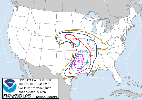
hail risk for the day

towers finally popping!

tall, leaning tower of a storm near omaha now

first big tower to go up

another storm trying to develop

tornado warned storm south of wahoo, ne

pic of storm west of omaha

again, notice the hail shaft just to the left of the middle

again

Thursday, April 8, 2010

4/5/10 First chase of 2010 season

Well i went out on my first chase of the new season this past monday. Unfortunately didn't see much, but it was nice to get out since the last time i had gone out was back in may of last year, before the malibu was wrecked. the day before i set up the laptop mount, with some great help from my wonderful wife, and got the car "ready". i was excited to try out some new stuff i had received over the the past several months. last year i had a garmin that i of course used for navigating. it was pretty helpful obviously, but using it had some restrictions, like map details and having to type in stuff while trying to drive, etc. so i bought microsoft streets and maps and put that on my computer. it does alot of the same things as the garmin, but it also has maps that are alot more detailed and easy to navigate around. the other nice thing that came with it was a gps puck. this is just a cord with a small gps receiver on the end of it that i can plug into my computer and then i can use gps on the streets and maps program. thats the other reason why i bought this software bc i can also use the gps function to then plot where i am at on my fancy radar program i have, grlevel3. this is nice bc then i know exactly where i am at in relation to the storm.
alright back to the chase! the setup today was a strong warmfront that was lifting north during the day into southeast nebraska and eastwards along the missouri/iowa border. south of the front temps were into the 80's and north of the front omaha basically stayed in the upper 50s all day. there was incredible shear along this front. at one point the 0-1 km helicity was 600 m/s2!! that's at least 4x the amount normally needed for rotating storms and tornadoes!! unfortunately there wasn't really anything to kick off storms that day so it was a "hope and pray" day for tstorms. hope that there would be something little to set off the storms or enough heating to get em to go up. i headed south along I-29 and as i reached just north of falls city, it became sunny and very warm instantly. i stopped at a place called oregon, mo, to wait for storms. the storm prediction center was monitoring the possiblilty of storms firing soon. i waited for about 45 mins watching the data on my computer. i decided that the front was getting a little to far north of me so i started to head north and east a little bit and ended up east/southeast of maryville, mo. for a while things looked promising as towering cumulus started to develop. but, unfortunately they couldn't sustain themselves and would fizzle out. finally around 7 i decided to call it a day, when my radar updated with some storms rapidly developing back to my southwest in northeast kansas. i was running out of daylight but thought i could race back to falls city, neb and meet them in that area right around sunset. i made it back in time, but on my way back they didn't really get much more severe than some hail. i stopped along the interstate at one point to try and get some pics of the storm but it was already too close. i am still getting familiar with all the settings on my new camera that i also got over the winter, so i spent most of the time fiddling with the camera rather than taking pics. it wasn't long though before the storm overtook me with heavy rain and some pea sized hail. it was here where i really used the gps feature now on my radar to drive back exactly into the core of the storm, but again it was only small hail. i continued to head home to omaha, arriving around 1030 pm. some elevated storms with small hail developed southwest of omaha and moved into town after midnight with some intense sheet lightning and heavy rain and small hail. i received 1/2 inch of rain at my house. so overall not a great chase but it was nice to get out for the first time in 10 months. the season is still real early, so i hope it gets better! here's a picture to the path i took that day, another nice thing about this new program i have!! i also included the risk probabilities and some of the hodographs that showed the intense shear in the sky.


path i took


severe probabilities for the day

tornado chances for the day


hodograph along ia/mo border


hodograph near carrol, ia-this was way north of the front though so no real chance of tornadoes here

Saturday, February 20, 2010

Winter pictures

I've decided to add some winter pictures that I have taken over the last couple of months. Normally, I only add stormchasing pictures but this has been an exceptional winter, with some of the deepest snowpack I have ever witnessed. I can only think of one other time there was much snow on the ground, and that was back in the winter of '97. Here in Omaha we have set several records this winter regarding snowfall and snowdepths. I'm going to include some links, webpages, and pictures from this winter. Of course as I write this, it is only the middle of February so another storm or two is quite possible, and as I write this we are expecting 3-6" tomorrow, the 21st of February.
The winter season actually started out fairly early with a storm at the beginning of October. Here at my house I measured 7" on October 10th. this was one of the earliest times ever recorded for snowfall. Here is a link to info on this early season snowstorm:
http://www.crh.noaa.gov/news/display_cmsstory.php?wfo=oax&storyid=31777&source=2

After the early snow, October saw no more major snowstorms, but remained very cold. In Omaha, it was the 3rd coldest October ever!
http://www.crh.noaa.gov/news/display_cmsstory.php?wfo=oax&storyid=35850&source=2

November was a drastic turnaround with the month being the 6th warmest ever in Omaha!
http://www.crh.noaa.gov/news/display_cmsstory.php?wfo=oax&storyid=43531&source=2

Then came December with two major snowstorms. The first hit on Dec. 8th and 9th and brought 9-14" of snow to most of eastern nebraska and western iowa. I ended up with just about 12" here at the house. After most of the snow had ended winds picked up and gusted over 50 mph! here is a link to the storm info:
http://www.crh.noaa.gov/news/display_cmsstory.php?wfo=oax&storyid=44116&source=2

This storm was forecast for days with very good model consistency. I've included some of the forecast snowfall amounts from wxcaster.com in the days leading up to the storm.


The next major snowstorm was the Christmas blizzard from Dec. 24th-26th. This storm was a monster storm with totals measured in feet in many places and also very strong winds. In fact this storm was so large that at one point it was drawing in airmasses from the atlantic ocean, the pacific ocean and the Gulf of Mexico!! Snowfall here in Omaha ranged from 12"-15". This storm set more records and December snowfall records were also set. Here is a link to the storm info:
http://www.crh.noaa.gov/news/display_cmsstory.php?wfo=oax&storyid=45186&source=2

some more links:
http://www.crh.noaa.gov/news/display_cmsstory.php?wfo=oax&storyid=45268&source=2
snowfall in southeast south dakota and northwest iowa:
http://img199.imageshack.us/img199/3484/sesdtotals.png
link to website that has info for all regions affected by this massive storm:
http://snowday.community.officelive.com/ChristmasBlizzard2009.aspx

again the models were fairly consistent on snowfall amounts. here's some forecast images:


here are some images of forecast amounts by the des moines wfo, and also a detailed map of snowfall totals:


here are some pictures taken by others from around omaha. omaha's snowpack was now near 2 feet with drifts out in the country of 12'-20'(that's feet)!!


Since the christmas blizzard we haven't had any major snowstorms. there have been a handful of minor to moderate accumulation snowfalls, i.e. less than 5" to keep our snowpack. Omaha has just broke its record of having at least 1" of snowfall on the ground with now 76 days(2/20). also with the very deep snowpack, temperatures have continued to be well below normal. normally during an el nino winter, temps are above average. the first part of january nearly broke records for cold. there were a few record lows on some evenings and schools had to close due to the severe cold and wind chills. i've included a link to the cold temps and a link to the other records for lengths of snowdepths broken this winter.
http://www.crh.noaa.gov/news/display_cmsstory.php?wfo=oax&storyid=46250&source=2
http://www.crh.noaa.gov/news/display_cmsstory.php?wfo=oax&storyid=47880&source=2

here are some pictures i took at the beginning of january from around the area and my backyard: